Somabay proper
The branded destination, including the peninsula hotels, homes and marina. Its published masterplan also includes Coves, Mesca and Baywest; the hotel cluster alone does not define its extent.
Official Somabay masterplan ↗ AN INDEPENDENT FIELD GUIDE
Understand the area
Explore the coast, compare hotel locations and distinguish Somabay, Travco’s Ras Soma and Emaar’s Marassi Red Sea.
THE INTERACTIVE ATLAS
Choose a view. Pick a place.
See how it all fits together.
Land: Natural Earth / © OpenStreetMap contributors · Sources & limits
THE AREA AT A GLANCE
Somabay is the branded peninsula destination. Ras Soma is Travco’s Almaza Bay Ras Soma. Marassi Red Sea is Emaar Misr’s separate project. Farther north, Qatari Diar’s planned project is reported between Makadi Bay and Soma Bay; its exact site remains unconfirmed.
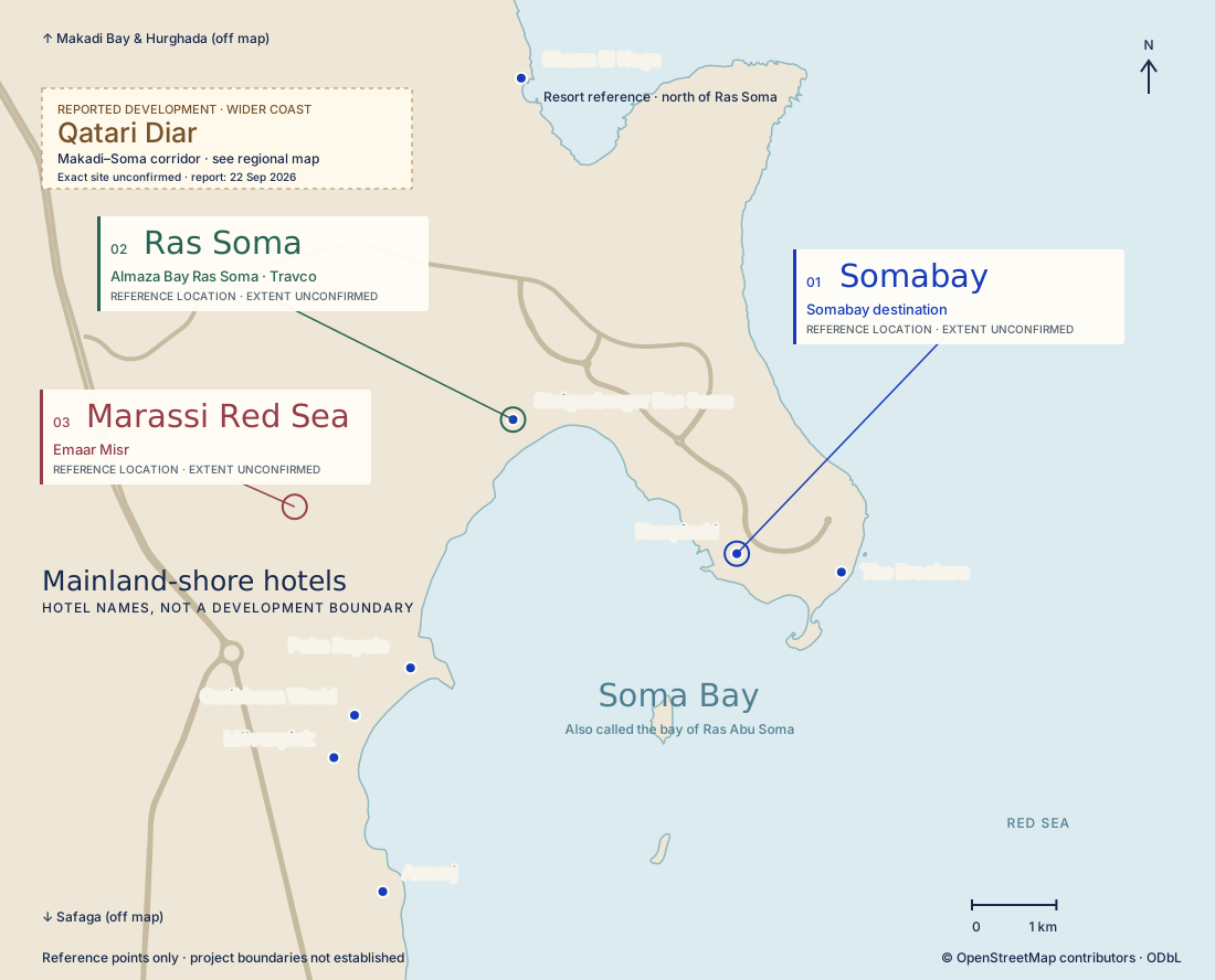
The branded destination, including the peninsula hotels, homes and marina. Its published masterplan also includes Coves, Mesca and Baywest; the hotel cluster alone does not define its extent.
Official Somabay masterplan ↗Travco’s separate Red Sea development northwest of the peninsula. Steigenberger Ras Soma is our map reference. Use the full name: the original Almaza Bay is on the North Coast.
Official Travco project ↗Emaar’s separate project on the mainland side of the wider bay. The marker follows Emaar’s own location link; it does not show the size of the site or identify a visitor entrance.
Official Emaar project ↗ZOOM OUT · THE RED SEA COAST
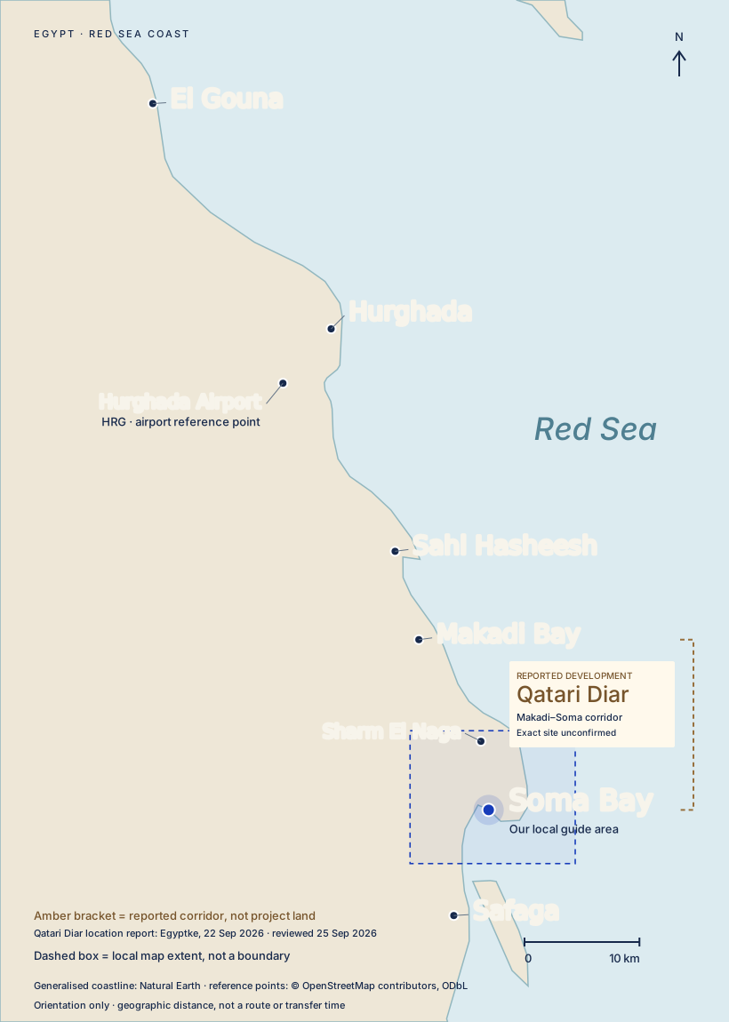
“Soma Bay” can mean the peninsula destination or the wider bay in hotel listings and conversation. Before arranging a journey, establish the exact hotel, home or venue. Somabay, Travco’s Ras Soma and Emaar’s Marassi Red Sea are separate project identities. The mainland-shore hotel grouping is a guide category, not another development or an administrative district.
This is the branded Somabay destination. Its homes and facilities share the peninsula with hotels including Kempinski, ROBINSON, Sheraton, The Cascades and The Breakers. The marina is one of its everyday shopping and dining hubs. Somabay’s published masterplan also includes Coves, Mesca and Baywest: “Somabay proper” should not be reduced to the hotel cluster alone. The masterplan is not a georeferenced property boundary.
If you are visiting a home, let your host arrange the arrival details. If you are visiting a venue, ask it who handles entry. Entering the destination and using a particular hotel, beach or sports facility are separate arrangements. A booking should not be treated as proof of both.
Browse peninsula places · Check facility access
Palm Royale, Sentido Caribbean World, Mövenpick Waterpark and Amwaj Beach Club sit on the mainland shore, across the bay from the peninsula. A hotel address containing “Soma Bay” does not necessarily mean it is inside the peninsula destination.
Tell your driver the full hotel name and agree the entrance or pickup point. Do the same when booking a meal or activity: accommodation at a mainland-shore hotel does not establish access to facilities on the peninsula. The map shows relative positions, not a walkable connection across the bay.
Travco now presents its Red Sea development as Almaza Bay Ras Soma. This is separate from Somabay, and from the original Almaza Bay on Egypt’s North Coast. Ras Soma lies northwest of the peninsula. Steigenberger Resort Ras Soma is the reference hotel shown on the map. Give its full name when arranging a transfer; “Soma Bay” alone leaves room for confusion.
Check access, restaurant bookings and activities with the Ras Soma operator concerned. Do not assume that arrangements made with a peninsula venue also apply here.
Marassi Red Sea is an Emaar Misr development. Emaar’s official location link places its reference point on the mainland side of the wider bay, west of the peninsula hotel cluster and southwest of the Ras Soma hotel reference. It is not a neighbourhood within the branded Somabay destination.
The marker shows Emaar’s published location, not the extent of its land, a confirmed entrance or evidence that advertised facilities are open. Use the full name Marassi Red Sea to distinguish it from Marassi on the North Coast.
Ras Abu Soma is a geographical name used for the peninsula/headland and its reef. You will also encounter “Ras Abu Soma Bay” in hotel descriptions. ORCA uses Ras Abu Soma for the peninsula and reef; Steigenberger uses it in descriptions of bay views.
It is not an additional development in this guide, and it is not a reliable substitute for a pickup address. If someone gives you this name, ask which hotel, dive centre or meeting point they mean.
The Breakers hotel and ORCA dive centre are together on the peninsula’s eastern side. The associated 7 Bft KiteHouse is a different location: The Breakers describes an eight-minute shuttle from the hotel. That is the hotel’s published transfer description, not a journey estimate for your starting point.
For a dive, kite session or boat trip, ask the operator to send the meeting point for the activity you booked. The hotel reception, marina and watersports base are not interchangeable. Our shore experiences map now includes a mapped KiteHouse building reference. It is not a confirmed entrance or meeting point; use the operator’s arrival instructions.
Sharm El Naga lies north of Ras Soma. The local map uses the mapped Sharm El Naga Resort as a reference for the area; it does not identify a verified beach entrance or establish visitor access. Ask the resort or activity operator for your exact meeting point and any entry arrangements.
The regional map puts the destinations in order from north to south: El Gouna, Hurghada, Sahl Hasheesh, Makadi Bay, Sharm El Naga, Soma Bay and Safaga. They are separate locations along the same coast. A listing described as “Hurghada” may need a more precise destination name before you can plan the journey.
Hurghada Airport is marked separately from the city. For a transfer, give the driver the airport or pickup venue and the full name of your destination. The dashed rectangle shows the local map’s coverage, not a resort boundary.
Hurghada and its airport are north of this local map; Safaga is south. Their off-map labels show direction only. No airport, town-centre or gate journey times are inferred from the map scale.
The interactive atlas reuses the reference locations and source geometry below. Its regional coastline is another crop of the same Natural Earth dataset; its local coastline uses the same OpenStreetMap extract. Distance mode calculates the great-circle separation between the editorial Soma Bay area point and the selected reference using the haversine formula. Values are rounded to a kilometre, or a tenth of a kilometre below 10 km. These are approximate straight-line comparisons, not routes, driving distances or transfer times. No live location is requested.
The coastline and selected main roads come from an OpenStreetMap extract retrieved on 25 September 2026. The seven original hotel points use saved OpenStreetMap geocoding results checked on 17 September 2026; the Sharm El Naga Resort point was retrieved on 25 September 2026. Points represent mapped features, not verified entrances. The coastline and location data are © OpenStreetMap contributors, available under the Open Database Licence.
The three project callouts use reference points: Kempinski for Somabay, Steigenberger for Ras Soma, and Emaar’s published location link for Marassi Red Sea. Callout lines are label leaders, not boundaries. Project names and affiliations were checked on 25 September 2026 against Somabay’s overview and masterplan, Travco’s Ras Soma page and Emaar’s Marassi Red Sea page. This is a retrieval date, not a publication date or an operator confirmation.
Exact project perimeters remain unconfirmed. The Somabay overview is illustrated, Travco’s 2023 brochure (broker-hosted copy, page 16) is conceptual, and Emaar’s September 2026 brochure (page 13) includes a regional locator. These do not establish a complete set of neighbouring, georeferenced boundaries. The separate satellite explorer overlays supplied artwork for comparison with the ground. Those approximate image fits are not verified project perimeters; a developer-confirmed boundary plan is still needed for ownership outlines. The local map also leaves out gate pins, minor roads and unverified service locations. It is an orientation map, not a navigation, beach-access or reef-safety chart. The 1 km scale is geographic distance, not road distance.
The regional map uses a generalised Natural Earth land layer rather than detailed shoreline mapping. El Gouna, Hurghada, Sahl Hasheesh, Makadi Bay and Sharm El Naga reference points were retrieved from OpenStreetMap on 25 September 2026. Airport and Safaga points come from the 17 September research; the Soma Bay regional label is an editorial point within the wider bay. The 10 km scale is geographic distance, not a road journey. Detailed boundaries and entrances are not established by any of these points.
Area descriptions are cross-checked against Steigenberger’s hotel page, ORCA’s Soma Bay page and The Breakers’ KiteHouse information. Published descriptions do not establish your access entitlement.
A news report published on 22 September 2026 places Qatari Diar’s planned Red Sea development between Makadi Bay and Soma Bay on the Hurghada–Safaga road. We show that broad corridor, with no project pin or shaded land parcel. The corridor does not establish which properties lie inside the project. Qatari Diar’s Egypt page, reviewed on 25 September, mentions future Red Sea projects but does not locate this one precisely. Coordinates, an entrance, a boundary and a distance estimate remain unavailable. Publication and review dates are separate; this is news-supported context, not developer confirmation.
Palm Royale Resort · Source date not stated · Retrieved 17 Sept 2026
No airport distance, room count or day-use policy; news items dated 2024-2025.
Accor / Mövenpick · Source date not stated · Retrieved 17 Sept 2026
No address, phone or room total on the fetched page.
Amwaj Beach Club · Source date not stated · Retrieved 17 Sept 2026
No room count; km marker only from third-party snippets.
Caribbean World Resorts · Source date not stated · Retrieved 17 Sept 2026
Templated, repeated copy; links onward to the Sentido site.
Sentido Caribbean World Soma Bay · Source date not stated · Retrieved 17 Sept 2026
Loaded in the browser pane (blocked curl). Phone numbers found in footer; no km marker on page.
H World International / Steigenberger · Source date not stated · Retrieved 25 Sept 2026
Address given as 'Safaga Road, 55 KM'; room total not stated.
Wikipedia contributors · Source date not stated · Retrieved 17 Sept 2026
Tertiary; useful for distances and peninsula dimensions but each figure needs a primary source before publication.
OpenStreetMap contributors · Source date not stated · Retrieved 17 Sept 2026
Coordinates are OSM feature centroids (hotels/resorts as areas), not entrances. ODbL attribution required. Nominatim usage policy: light use only.
ORCA Dive Clubs · Source date not stated · Retrieved 25 Sept 2026
No prices, hours or non-guest policy.
The Breakers · Source date not stated · Retrieved 25 Sept 2026
Hotel states an eight-minute complimentary shuttle to KiteHouse. Does not establish an entrance coordinate or every audience entitlement.
OpenStreetMap contributors · Source date not stated · Retrieved 25 Sept 2026
Coastline and selected roads from OSM API bounding box 33.925,26.81,34.02,26.89. Hotel reference points from SRC-037 (17 September). No entrance verification, access rights or resort boundaries. ODbL attribution and downloadable source data accompany the map.
OpenStreetMap contributors · Source date not stated · Retrieved 25 Sept 2026
Five new destination queries on 25 September 2026. Map references only, not entrances or verified boundaries. See site/map-data/regional-geocodes.json and sharm-el-naga-geocode.json. Airport and Safaga use SRC-037; Soma Bay label editorial.
Natural Earth · Source date not stated · Retrieved 25 Sept 2026
Public-domain generalised coastline for regional orientation. Scale is 1:10 million, not 10-metre resolution. Clipped to 33.54–34.18 E, 26.68–27.48 N. Not detailed navigation geometry.
Somabay · Source date not stated · Retrieved 25 Sept 2026
Project identity supported; exact development boundary and visitor access not established.
Travco Properties · Source date not stated · Retrieved 25 Sept 2026
Project identity supported; exact development boundary and visitor access not established.
Emaar Misr · Source date not stated · Retrieved 25 Sept 2026
Project identity supported; exact development boundary and visitor access not established.
Qatari Diar · Source date not stated · Retrieved 25 Sept 2026
Official page mentions future Red Sea projects; does not establish an exact location or boundary for this development.
Egyptke · Source dated 22 Sept 2026 · Retrieved 25 Sept 2026
Secondary reporting, not developer confirmation. Broad corridor only; no geographic coordinates, verified entrance or site boundary. Timing and land handover claims are not adopted.